NRM ALKIS

Integrated Data storage and information retrieval of land register data in Smallworld GIS

The product NRM ALKIS is based on Smallworld GIS and supports to integrate data retention and information retrieval of land register data in the data model ALKIS. It is ideal for energy suppliers and municipalities that need the land register data as a base layer for their GIS.

ALKIS (official information system for real estate cadaster) is an important tool for property and building management in Germany. It is a central database with information about ownership, type of use, size and position of properties. It has also information about buildings and their properties.

ALKIS was introduced in 2010 and replaced the former forced real estate cadaster. It is a complex IT application, based on geodata infrastructure and operated by the survey and cadaster authorities of the German federal states.

These authorities levy and maintain the data for ALKIS. To ensure high accuracy and topicality of the data, they use the most modern survey technologies, such as satellite navigation and laser scanning.

ALKIS is for management of plots and buildings as important as for the planning and realizing of construction projects. Architects and civil engineers can get access to the ALKIS information, for example to determine the location and size of a property or to get building permits.

From 2024 on ALKIS data will also be available in GeoInfoDok 7.1 format.

We support your use of ALKIS and NRM ALKIS via consulting and training services as well as with migration and homogenization. In addition, our product portfolio includes the GC ALKIS Add-ons-Bundle with four extensions for NRM ALKIS.

Some of our consulting services for the use of ALKIS:

  • Transfer of your own data and land register data to ALKIS – including data migration
  • Replacing the old land register VE through ALKIS VE
  • Consulting about necessity of homogenization 
  • Migration of several ALKIS databases into one – including data transfer
  • Automated NAS updates
  • Implementation of GeoInfoDok 7.1

The GC ALKIS Add-ons-Bundle

Our four extensions for NRM ALKIS:

GC ALKIS Auswertung

Our GC ALKIS AUSWERTUNG offers to create interim tables with results. Therefore you only have to initiate given procedures via a click on the surface. The configuration file for this is compiled in GC Joins.  

GC ALKIS Zeitanalyse

With GC ALKIS Zeitanalyse you can show changes in the ALKIS database. For example, you define the start and end point and the system shows all changed, deleted and newly inserted ALKIS database objects for this period.

GC ALKIS Gebäudeschraffur

GC ALKIS Gebäudeschraffur offers 3 new menu options to show ALKIS buildings: ALKIS, only hatching and ALKIS + hatching.

GC ALKIS Nutzungsart

GC ALKIS NUTZUNGSART is a new object class that automatically adds objects from usage – vegetation, usage – traffic, usage – water and usage – estate.  

GeoInfoDok 7.1

From 2024, ALKIS data is also available in the GeoInfoDok 7.1 format. We would like to inform you about the conversion and provide you with support. The relevant cadastral offices can give you information about the current availability of NAS data in GeoInfoDok 7.1 format in the respective federal state.

AAA®-Data model

NRM ALKIS contains the complete AFIS-ALKIS-ATKIS-data model.  In this data model the data of the real estate cadaster, the point data of the survey and the data of the typographical-cartographic state survey are available. 

Data analysis and complete history

Besides special analysis opportunities for ALKIS data you can also get the complete history of the cadastral data and evaluate them at any time.

Data import 

It takes only a few mouse clicks to import and export ALKIS data via NAS (standard-based exchange interface).

Managing cadasral data GC ALKIS Verfahrenslösung (process solution)

The GC ALKIS Verfahrenslösung enables you to systematically record, process, and provide information on ownership structures, types of use, boundary points, and topographical features—all in a central Smallworld database. The APK, DHK, and EQK components efficiently support and validate the continuation of survey data.

Your contact
Marcus Praschan
Marcus Praschan
Account manager
Phone: +49 2364 9218-86
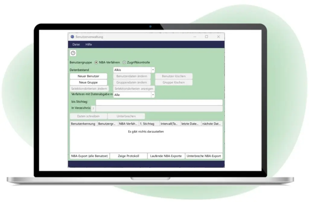
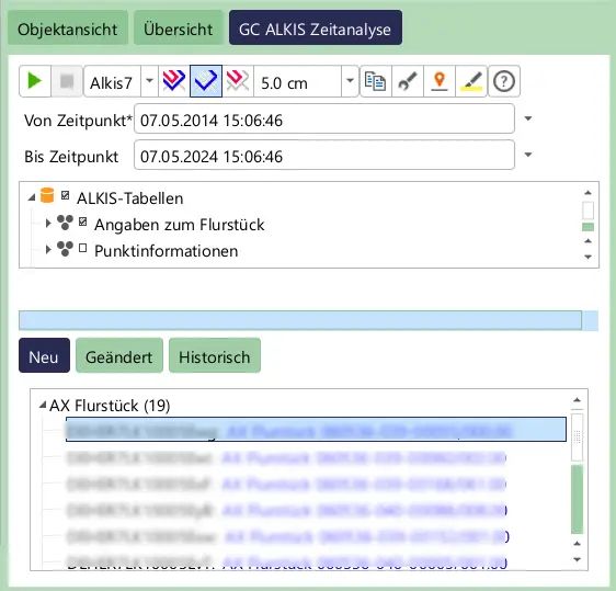
By acquiring and using the standard Smallworld NRM ALKIS, we have significantly improved the company`s geoinfrastructure. We were able to automate the weekly land register data update with the help of the NBA interface. Additional topographical, electronic survey images are imported directly into and processed further by the data model.
Klaus Berns
Hertener Stadtwerke GmbH
Two years ago, we standardized and automated our processes with the acquisition of NRM ALKIS. For example, we also manage our additional cadastre in NRM ALKIS parallel to the official one. Furthermore, we have automated the NBA process and now automatically import the data updates into the data model. We also maintain several federal states in one ALKIS database.
Tobias Hag-Sen
NBB Netzgesellschaft Berlin-Brandenburg